
Chapter 16 Section 4 Maps of the Song Dynasty
During the Five Dynasties and Ten Kingdoms period, wars and annexations among various regimes continued, and military, diplomatic and political needs made some thematic maps, especially military situation maps, more important.Until the early years of the Northern Song Dynasty, such maps played an important role.The Northern Song Dynasty was in a situation of co-existing with the Later Shu, Southern Tang, Northern Han and other separatist regimes and confronted with the Liao and Xixia. It has always focused on this kind of topographic map mainly showing the military situation.
In the second year of Qiande (964 A.D.), the Song Dynasty captured Sun Yu and Yang Juan [juan Donation], the secret envoys sent to the Northern Han Dynasty by Later Shu. The places where the troops are stationed, the road mileage, etc. are all drawn on the map.When Wang Quanbin was sent to attack Shu, Song Taizu personally handed him the map, and also pointed out on the map the place where Shu set up the iron chain pontoon bridge on the Yangtze River in Kuizhou.The importance of this picture to the Song Army is self-evident.In order to persuade Song Taizu to send troops to recover the sixteen prefectures of Youyan occupied by the Liao Kingdom, General Cao Han specially drew a map of Youyan, which made Song Taizu feel tempted after seeing it.It is said that in order to express his reluctance to attack Duan's Dali Kingdom, Song Taizu used a jade ax to draw the Dadu River as the southern boundary of the Song Dynasty on the map.
In July of the second year of Zhidao (AD 996), Song Zhenzong, who had just ascended the throne, wanted to understand the mountain and river situation in frontier counties and counties, and specially sent Yang Yungong, Dou Shenbao, Li Yun and others to survey and map various places.In September, Yang Yungong and others painted "Shanchuan County Xingsheng Map" and presented it.A few days later, Zhenzong summoned the ministers in the Zifu Hall to look at the map of the western frontier together, and pointed to the military facilities on the map to explain his deployment.This kind of map is generally divided into regions. Due to the large space and rich content, the number of drawing is naturally not limited to the second year of Dao.Zhenzong hung them on the four walls of Zifu Hall as a basis for deploying military affairs and arranging them to ministers.For example, in October of the fourth year of Xianping (AD 1001), he presented the "Map of the Twenty-Three States of Shaanxi" to the minister, detailing the situation of mountains and rivers, dangerous places and the distribution of ethnic minorities.Pointing to the "Lingzhou Map" on the north wall, he said: "This is drawn by Feng Ye, and the mountains and rivers are drawn in great detail." Pointing to the "Gansha, Yiliang and other states" hanging on the south wall, he said: "This picture The painting shows that the source of the Yellow River is still outside the Jishi Mountain, which is different from the statement in "Yugong." The "Khitan National Boundary Map" on the north wall records that the Khitan land is 1,500 miles from north to south and 900 miles from east to west. Zhenzong said: "The place is reversed. Not too bad, it's a pity that the states of Yan and Ji were taken over by this alien race."
Due to the emperor's preference for such maps, ministers contributed maps one after another, or strengthened their suggestions by presenting maps.For example, Zheng Wenbao advocated abandoning Lingzhou, and once presented "Hexi Longyou Tu".When Shengdu was on a mission to Shaanxi, he visited various places, collected materials, and drew a map of the Western Regions, which was awarded.Later, Zhenzong personally summoned him to ask questions, and Shengdu drew the Great Wall of Qin Dynasty, the station of Jiedu envoys in Tang Dynasty, mountains, roads, settlements, military facilities, etc. into a detailed "Hexi Longyou Map" based on the five counties of Hexi in Han Dynasty.This is a map of the historical military situation in the Northwest Territories.
Because the content recorded in the map is very detailed and plays an important role in politics and military affairs, foreign countries will use the map as important information to understand the Song Dynasty.During the Xining period (1068-1077 A.D.), envoys from Goryeo came to pay tribute to the Song Dynasty.Every time they passed a state or county, they asked the magistrate for a local map, and the magistrate provided them with a very detailed map, with mountains, rivers, roads, dangers and other aspects clearly drawn.When they arrived in Yangzhou, they also asked the state officials for a map.At that time, the prime minister Chen Shengzhi happened to be the magistrate of Yangzhou, so he lied to them that he wanted to see what kind of map Liangzhe Road gave them so that they could draw it according to the same specifications.After receiving these maps, he burned them all and made a detailed report to the emperor.The Koryo envoys may not be for military purposes, because it is impossible for Koryo to take any military action against the Song Dynasty, and according to the records of "Liangxi Manzhi", when the Song envoy Lu Duoxun was sent to Korea in the early Song Dynasty, he also brought back soldiers from the states of Koryo. map, so there are precedents for the Goryeo envoy's approach.However, since Chen Shengzhi realized the seriousness of the problem and officially reported it, the imperial court will definitely take measures in the future to stipulate that no maps of various places should be provided to foreign envoys.As for between enemy countries, the secrecy of the map is not to mention.
Out of administrative needs, the Song Dynasty stipulated that all states should submit maps every leap year.Later, it was changed to report every other leap year.In the fourth year of Chunhua (994 A.D.), Song Taizong ordered the painters to put together 100 pieces of silk, and draw a huge "Tianxia Map" based on the seized maps of various countries and the maps reported by each state, which was hidden in the royal archives.But such a large map may not have much practical value, so Song Zhenzong still used a single map by region in the future.In the fourth year of Xianping (AD 1001), Wu Shu, an official in charge of maps, pointed out that the boundaries of the states were crisscrossed, and the maps drawn by the states were often not well put together. ) each time to draw a map of the states of the road and report, and to draw a full map of the road every 10 years.His opinion was adopted.After Xu Zhongxuan became the chief executive of the Beihai Navy (an administrative division in the Song Dynasty), he felt that the territory under the jurisdiction of the army was fully qualified to be promoted to a state, so he drew a map and reported it. Sure enough, it was approved, and the Beihai Navy was upgraded to Weizhou.The importance of this type of political district map can be seen from this.
Cities are the seat of political districts, so the drawing of maps of cities, especially capitals or famous historical cities, has always been paid attention to. In the Tang Dynasty, some detailed city maps came out.It can be inferred from the stone inscription maps left in the Song Dynasty that there were many city maps drawn at that time.
Since Pei Xiu's Yugong Regional Map, the tradition of compiling historical maps has not been interrupted, but the earliest historical atlas preserved at present is the Song Dynasty's "Geography of the Past Dynasties" (also known as "Geography picture").This atlas was compiled by Shui Anli in the Northern Song Dynasty and supplemented by Zhao Liangfu in the Southern Song Dynasty.In the Song Dynasty, it was reprinted and circulated many times. Up to now, Japan’s Toyo Bunko still has a collection of Song engraved editions marked “Xiyu’s Family Seal, Chengdu Prefecture, Xichuan”.There are 44 maps in this atlas, and each map has a title and a description after the map.From the legendary Emperor Ku [kuku] to the Song Dynasty, each dynasty had at least one map and as many as five.The first one is "General Map of the Ancient and Modern Huayi Region". The outlines of the coastline, rivers, and the Great Wall in the picture are similar to the "Huayi Map" on the stone in the seventh year of Fuchang (AD 1136). It is also basically consistent with the text description on "Huayi Tu".The west of the 27th "Ten Dao Map of Tang Dynasty" is marked with "Xingxiu Sea", which may be the earliest known place name on the map.The last one is "A Map of the Promotion of the Holy Dynasty and the Abolishment of the Prefectures and Counties" (the "Sage" was changed to "Song" in the engraved version of the Ming Dynasty), which contains the establishment of the Southern Song Dynasty, indicating that it has been added.It is worth noting that the Song edition of this atlas is overprinted in red and black colors, which accurately reflects the characteristics of the original work of "ancient ink and modern Zhu".This also proves that the historical map drawing method pioneered by Jia Dan to display ancient and modern content in different colors has been widely adopted by historical map authors.
Historical geographic maps also include various thematic maps. For example, in the third year of Yuanfeng (1080 A.D.), Liu Jingyang and Lu Dafang were ordered to draw a historical map of Chang'an (now Xi'an, Shaanxi). ) is two inches equal to one mile, and ancient palaces, city walls and other buildings are drawn on the map.Afterwards, the floor plan in "Chang'an Zhitu" drawn by Li Haowen was based on this picture.
The "Six Classics Map" compiled by Yang Jia around the 25th year of Shaoxing (AD 1155) (Fig. 13) is the first printed map in my country, which is more than the first printed map in Europe (Fig. 14). It is about 200 years earlier, but the level of cartography is much higher than the latter.
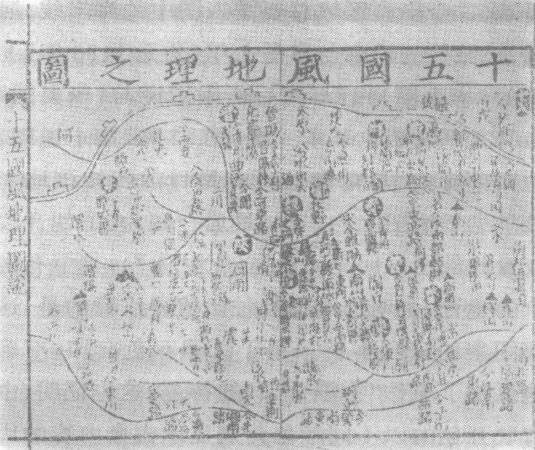
Figure 13 "The Map of Geography" contained in Yang Jia's "Six Classics Map"
Figure 13 "The Map of Geography" contained in Yang Jia's "Six Classics Map"