
Chapter 6 Section 5 Map of Fangma Beach
"Fangmatan Map" is named after it was unearthed in Fangmatan, Xiaolongshan, Tianshui City, Gansu Province in 1986. The seven maps are drawn with ink lines on the AB (front and back) sides of four pine boards.The four boards are basically equal in size and numbered according to the order of unearthed: the first board is 26.7 cm long, 18.1 cm wide, and 1.1 cm thick. The wooden board is 26.6 cm long, 15 cm wide, and 1.1 cm thick, drawn on one side, and is called Figure 3; the third wooden board is 16.5 cm long, 18.1 cm wide, and 1.1 cm thick, and the sides A and B are respectively Figure 4 and Figure 5. Map No.; the fourth board is 26.8 cm long, 16.9 cm wide, and 1 cm thick. The maps on both sides are No. 6 and No. 7 (Fig. 2-8).

Figure 2 Tianshui Fangmatan Warring States Map No. 1

Figure 3 Map No. 2 of Fangmatan Warring States Map in Tianshui

Figure 4 Map No. 4 of Fangmatan Warring States Map in Tianshui

Figure 5 Map No. 3 of Fangmatan Warring States Map in Tianshui

Figure 6 Map No. 5 of Fangmatan Warring States Map in Tianshui
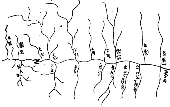
Figure 7 Map No. 6 of Fangmatan Warring States Map in Tianshui

Figure 8 Map No. 7 of Fangmatan Warring States Map in Tianshui
The planed surface of the first wooden board was severely worn and broken into three pieces, which were placed in three places in the coffin; the second, third, and fourth wooden boards were intact, and the planed surface was as clean as new.This shows that the two maps on the first board were drawn earlier and have been used for a long time; the maps on the other three boards were drawn later and have not been used for a long time.
Among these seven pictures, except that No. 5 is a semi-finished product, the other six pictures can be divided into two groups according to the water system they draw:
The first group consists of Figure 1 and Figure 2. Figure 2 is a partial enlarged view of the left half of Figure 1.Judging from the word "上" marked at the bottom of the map, this group of maps belongs to the vertical north-south direction, with the upper north and the lower south, which is consistent with the direction of modern maps.However, it is opposite to the direction of the topographic map unearthed at Mawangdui, which shows that there is no consistent regulation on the layout direction of the map in the Qin and Han Dynasties. It can be up north and down south, or it can be up south and down north.
The second group includes figures 3, 4, 6, and 7. Map No. 3 is a joint relation map of the watershed headstream area of Map No. 4 and Map No. 5, Map No. 4 is a partially enlarged map of Map No. 5, and Map No. 7 is a partially enlarged map of Map No. 3.The layout of this group of pictures is also arranged vertically in the north-south direction, but the annotations on the pictures are not all facing the readers, but are arranged in the east or west direction.However, judging from the texts annotated on the tributaries of the rivers drawn in Map No. 4 and No. 6, the direction of this group of maps is consistent with that of the first group of maps. Obviously, this is also in line with the mapping habits of the map author.
460 bamboo slips were unearthed from the same tomb, and experts named them "Ri Shu" and "Tomb Master Ji". "Tomb Owner's Story" consists of eight bamboo slips, which record the experience of the tomb owner named Dan.According to the content of "Tomb Master", other burial artifacts and relevant historical materials, it can be roughly concluded that:
Dan, the owner of the tomb, has a high level of cultural accomplishment and extensive knowledge. The "Sun Book" buried in the tomb includes theories of astronomy, calendar, rhythm, divination, witchcraft, and the five elements. A comprehensive collection of cultures.In addition to maps, there are writing brushes, counting chips, wooden rulers and other utensils in the tomb.
Dan, the owner of the tomb, was sentenced to punishment for wounding people with an arrow in the Yuanlili of Ying County in the seventh year of Qin Huiwen's Queen Yuan (318 BC). (315 B.C.) participated in the battle of the Qin Dynasty and Zhao Quyiqu. This may be due to his rich geographical knowledge and social status, he got a chance to redeem his crimes, so he was mainly engaged in the staff in the army. clerical.After the end of the four-year war, perhaps because he was sentenced to exile, or because he himself did not want to return to his hometown, Dan, the owner of the tomb, moved to burn (fanfan) Shiguan, a fortress in the southeast of Ying County, until the eighth year of King Xiangzhao of Qin Dynasty (formerly 299) died of illness in Yanshiguan, and was buried in the cemetery on the north side of the pass - today's Shuifangmatan.
The four pictures in the second group of "Fangmatan Map" are all large-scale maps drawn with the Fanshiguan as the base point of surveying and mapping, which proves that these were drawn by Dan, the owner of the tomb, during the period of Fanshiguan, and the time should be Queen Huiwen. Between the fourteenth year of Yuan Dynasty and the eighth year of King Zhaoxiang, that is, around 305 BC.The first group of pictures is based on the tributaries on the north bank of the upper reaches of the Weihe River centered on Yu County, which has nothing to do with the Fanshiguan area, and the accuracy is not as good as the second group of pictures, and it has been used for a long time. The work was done when the county wall was away, so the drawing technique is not as good as in the later period.
From the analysis of the place names on the maps and the depicted water systems, valleys, and pavilions, the first group of maps covers the entire Weihe River Basin to the northwest of Boyang Town, Shuishi today.The region shown in the second group of maps includes the Huamiao River and the upper reaches of the Dongke River in the north and south of Fangmatan today. Together, form a larger range.
The drawing features of "Fangmatan Map" show a fairly high level of technology, as shown in:
(1) The overall framework of the drawing is formed by the prominent water system.The first map group takes the Weihe River in the northwest of the current Boyang River as the main stream, and a total of 10 first-level tributaries, 17 second-level tributaries, and four third-level tributaries are drawn on the north and south banks.In the second picture group, the north stream water system takes the upper reaches of the Dongke River as the main stream, and a total of nine primary tributaries and one secondary tributary are drawn on the east and west banks; the south stream water system takes the upper reaches of the Huamiao River as the main stream, and a total of 23 streams are drawn on the east and west banks First-order tributaries, more than 24 second-order tributaries and four third-order tributaries.The framework of the water system drawn by the two map groups is basically similar to the water system map of the corresponding modern area. The relationship between trunk and branch is clearly expressed. Injected, and all injected in the downstream of the river, so as not to be confused with the names of the secondary and tertiary tributaries.Before the emergence of precise latitude and longitude mapping, the method of using water systems to form the overall framework of the map was quite advanced.With this method of mapping, as long as the water system is accurately represented, the representation of other geographical elements can achieve the desired effect.This method has become the tradition of map drawing in China, and is still the basic method of drawing regional maps.
(2) Highlight key points and expand the main area.Three of the six pictures are partial enlarged pictures drawn to highlight the key areas. Map No. 2 is an enlarged map of the western water system of Map No. 1, Map No. 7 is an enlarged map of the Beiliu water system of Map No. 3, and Map No. 4 is an enlarged map of the upstream water system of Map No. 6.In the same map, there are also main and sub-regions. For example, Map No. 1 is drawn with the Qiqiu as the core, so the area around the Qiqiu is the most prominent. Map No. 2 highlights the Guangcheng River system, while other areas are relatively brief.This method is followed by the map of Mawangdui. The "Garrison Map" is a partially enlarged map of the "Topographic Map".To this day, highlighting the main area or adding a partial enlarged map is still a common drawing method.
(3) The concept of basic proportion has been formed.The intersection of main and branch streams, flow direction, flow length, and tree distribution shown on the map can be proved to be the results of field surveys.But when the author drew the first set of maps, it was basically just a schematic, without the concept of scale. For example, the Niutou River Basin was drawn larger than the Hulu River Basin in No. 1 map, but the fact is just the opposite.But when drawing the second group of maps, the author has made significant progress and formed a basic concept of proportion: the area of the two river systems in the north-south direction of map No. 3 is basically in line with the scale, and the basic scale of map No. 6 is roughly 1/100,000 , Figure 4 is also enlarged according to a certain scale.
(4) Form and apply the concept of joint graph.Although the regions shown in the first group of maps and the second group of maps are different, they have a certain internal connection, which is reflected by the relationship between the Sailibai Valley and the Dongke River.Map No. 7, No. 4, and No. 5 in the second group of maps draw completely different river basins, but there is a homologous relationship. Through the connection of No. 3, Map No. 7 and No. 4 and No. Graph homology relations are completely docked.In modern large-scale maps, the use of junction diagrams is very common, but in ancient maps, junction diagrams like Map No. 3 are discovered for the first time, and they are the first in China and the world.
(5) It has a set of representation methods for map elements.The four major elements of modern maps, terrain, water system, settlements, and traffic lines, all have corresponding symbols in these maps, but they lack experience and are not standardized enough at the beginning of application, so there are inevitably deficiencies.
In the figure, the water system is represented by a uniform curve, the primary and secondary relationship is relatively clear, the curve is natural, and the shape is eye-catching.But sometimes the strokes are heavy, which makes the line length of the source area thicker, and there is no change from thin to thick according to the direction of flow, so it is not as exquisite as the map of Mawangdui.
The 10 residential areas are indicated by adding words inside the rectangular symbols, which is easy to interpret and difficult to confuse.However, there is no distinction between the county level and the township level, and it is not as clear as the Mawangdui map.
Lines of traffic are represented by uniform thin lines.Although only one is drawn next to the main river in Figure 4, it was the main road leading to the south of the Qinling Mountains at that time (equivalent to the section from Fangmatan to Huangjiaping on the Shuidongquan-Liqiao Highway today), which has a significant role in the history of transportation. significance.
There are two ways to represent the terrain: one is the single-curve ridge method in the second map group, which is used to represent the watershed between the north and south water systems and the terrain on the northwest sides of the Nanliu water system; The mountain-shaped curve method is used to indicate the shape of the mountain, the trend of the mountains, and the position of the valley. It is clear and eye-catching, and the position is accurate.Unfortunately, this method was not applied to the remaining six finished drawings, probably due to the greater difficulty in drawing techniques.However, in Mawangdui's "Topographic Map" and "Garrison Map", the representation of terrain has been completely adopted in this way.The difference is that the "Topographic Map" added a halo line inside the closed curve and deleted other symbols, while the "Garrison Map" retained the symbols and expressed it with an unclosed single curve.The terrain representation method of the Mawangdui map is quite advanced, and it has the embryonic form of the closed curve method of the modern contour line. However, Map No. 5 of "Fangmatan Map" proves that this method has been formed in the Warring States Period.
In addition, two half-moon symbols are used to sandwich the river to represent six canyons on the map, which are vivid and clear at a glance.The Nuwa Temple is represented by a pavilion-shaped symbol, which is intuitive.Both symbols are still in use today.
"Fangmatan Map" is rich in content, and its accuracy and cartography have reached a relatively high level.Although compared with the Mawangdui map and later maps, they are still crude, but undoubtedly represented the most advanced level in the world at that time.
Figure 2 Tianshui Fangmatan Warring States Map No. 1
Figure 3 Map No. 2 of Fangmatan Warring States Map in Tianshui
Figure 4 Map No. 4 of Fangmatan Warring States Map in Tianshui
Figure 5 Map No. 3 of Fangmatan Warring States Map in Tianshui
Figure 6 Map No. 5 of Fangmatan Warring States Map in Tianshui
Figure 7 Map No. 6 of Fangmatan Warring States Map in Tianshui
Figure 8 Map No. 7 of Fangmatan Warring States Map in Tianshui