
Chapter 17 Section 5 Reconstruction of Nanhe River
Since the end of the Spring and Autumn Period, there have been canals connecting the Jiang and Huai Rivers.This canal starts from today's Yangzhou City in the south and ends in today's Qingjiang City in the north.It was successively called Hangou, Zhongdushui, Shanyangdu, Yangchu Canal, Huaiyang Canal, Huainan River, etc. in history, and it was called Nanhe in Ming Dynasty.Because it is also the necessary channel for the transportation of grain from the south to the north, and there are many problems, it is also one of the main objects of governance in the Ming and Qing Dynasties.
From the Yuan Dynasty to the early Ming Dynasty, this section of the canal was connected to the Hehuai River in the north of Huai'an City.Usually, the water level of the canal is high and the water level of the Yellow River is low, so the water in the canal is easy to lose.During the flood season of the Yellow River, the water level of the Yellow River is high and the canal is low. The flood and sediment of the Yellow River are easy to accumulate in the canal channel.In the early years of the Ming Dynasty, when Chen Xuan followed Song Li to manage the river transport, five dams named after benevolence, righteousness, propriety, wisdom and faith were built side by side at the junction of the river transport to prevent the loss of water in the canal and the influx of sand from the Yellow River.At that time, five dams were built to facilitate the dispersal of the dams by boats and ships, so as to reduce the waiting time.Later, because the dam was labor-intensive and time-consuming, Chen Xuan reopened the old road of Shahe River in the Song Dynasty under the guidance of the local elders, and built a gate every 10 miles or so on the road, and built five gates in total.The boats enter and leave the river, and change to this way. The boats open the gates, and the boats close them immediately.
While better solving the problem of river connection, Chen Xuan also properly handled the problem of navigation between rivers.Originally, only one mouth of the canal entered the river. Later, due to the accumulation of sediment on the north bank of the Yangtze River, the old mouth gradually silted up, so a new mouth had to be opened.By the Ming Dynasty, several canals connecting the river actually formed, such as Yizhen (now Yizheng) Canal, Guazhou Canal, Baita Hekou, Beixin Hekou, etc.The rivers are connected by many ports. Although there are defects such as heavy maintenance work and easy drainage, there are also many advantages.One is that the canal was already quite busy at that time, and there were many boats passing by, and more entrances and exits could avoid congestion.The second is that ships from various places can be transported nearby, which not only shortens the transportation route, but also reduces the risk on the river.Ships coming from the middle and upper reaches of the Yangtze River can enter Yizhen Yunkou in the west; tank ships traveling northward via Zhenjiang from the Taihu Lake Basin can enter Guazhou Yunkou, and grain ships coming from the Taihu Lake Basin via Mengdu or Deshengxin River , You can enter Baita River and Beixin River by crossing the river.Chen Xuan and others basically managed these ports, such as dredging port channels, building dams and gates, etc.Building gates at the mouth of the canal is a relatively complicated project, but it is convenient for boats to enter and exit; when the water level of the Yangtze River drops, the gates can be closed to prevent the water loss of the canal; when the tidal level of the Yangtze River rises, the gates can be opened to divert water.
In addition to the north and south ends, the Ming Dynasty also carried out large-scale renovation of the Nanhe River. The main projects were the construction of lake embankments and the Moon River, which gradually separated the lake transportation.
The Nanhe River has a very long waterway that is not divided into rivers and lakes, that is, natural lakes are used as waterways, and tank boats sail through the lakes.However, the lake is big, the wind is strong, and the waves are high, so boats and boats are often capsized.In order to prevent the lake waves from capsizing, at first, the Ming Dynasty decided to build a lake embankment to protect the boats and cross the waterway at the suggestion of Bai Conggui, an old man in Baoying.An earlier project was carried out in the ninth year of Hongwu (1376 A.D.), when 50,000 Huaiyang Dingfu were sent out, "to build Gaoyou Lake embankment for more than 20 miles, and Kaibaoying leaned on the lake for 40 miles to protect it. "("History of Ming Dynasty · Hequzhi III") Not only built dikes in Gaoyou Lake to prevent waves, to protect grain ships from navigating beside the dikes;During the reign of Xuande (1426-1435 A.D.), when Chen Xuan was in charge of the river transport project, he extended this project to Baima Lake, Panguang Lake and other lakes (Figure 4).
This embankment is a brick-and-soil structure, which is poor in wind and wave resistance. Although it can protect tank ships, it is easily destroyed by wind and waves, and the maintenance task is very heavy.In order to change this situation, during the Hongzhi period (1488-1505 A.D.), under the auspices of Bai Ang, the minister of household affairs, the Fuhe (Moon River or Yuehe) project began to be built.The complex river he presided over is called Kangji River, 40 miles long, a few miles away from Gaoyou Lake in the west, and in the east of the old canal, leading the lake water as a water source.Because it is far away from the lake, the wind and waves are not as good, so it is relatively safe.After Bai Ang, in the thirteenth year of Wanli (1585 A.D.), Li Shida, the censor of Caodu, adopted the suggestion, and crossed the Hongji Moon River in the east of Baoying Lake, with a length of more than 1700 Zhang.Then, in the 28th year of Wanli (AD 1600), Liu Dongxing dug Shaobo Moon River and Jieshou Moon River on the east side of Shaobo Lake and Jieshou Lake respectively.The former is 18 miles long and more than 18 feet wide, while the latter is more than 12 miles long.After this series of projects, the Nanhe channel has basically got rid of the threat of lake waves.
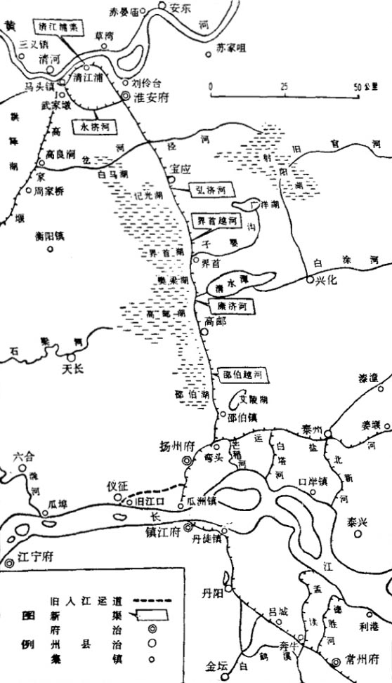
Figure 4 Harnessing of the Nanhe River between the Yangtze and Huaihe Rivers
Figure 4 Harnessing of the Nanhe River between the Yangtze and Huaihe Rivers