
Chapter 30 Section 10 Map of Mawangdui and Pei Xiu's "Six Elements of Cartography"
Like geography, the drawing of maps is related to governing the country, and it has also been valued by successive governments.In the pre-Qin period, people had drawn maps and used them for political, economic and military purposes.The pre-Qin classic "Zhou Li" said that the duty of Da Situ (official name) is to be the person who masters the map of the state, and uses the map to understand the mountains and rivers, the city, the products, the territory, etc.In another classic "Guanzi", there is a special "Map Chapter", explaining the importance of maps to military strategists. Only by understanding the terrain, landforms, distances and other conditions through maps can we "not lose the geographical advantage" and "know the priority of action".
In the Mawangdui Han Tomb in Changsha, three maps before 168 BC were unearthed, all of which were painted on silk.Two of them have now been published.The original map is unnamed, but it is now named "topographic map" and "garrison map" according to the content and nature of the map.These three maps, together with the aforementioned paper topographic map of the early Western Han Dynasty discovered in Fangmatan, Tianshui, Gansu, are the earliest maps based on actual measurements that remain in my country and in the world.
The topographic map is roughly drawn on a scale between 1:170,000 and 1:190,000.In the picture, mountains, rivers, settlements, roads, etc. are all drawn in a certain way.For example, a closed curve plus a halo line is used to indicate the direction of a mountain range; the upstream of a river is thin and the downstream is thick; Dotted line) indicates etc.
The garrison map is a color military map, with blue lines for rivers and lakes, black lines for mountains, and red frames on a black background to mark army garrisons. The defense lines of each garrison are divided by solid red lines, dotted red lines indicate military roads, and black circles indicate residential areas.The picture shows the deployment and command points of the nine garrisons.
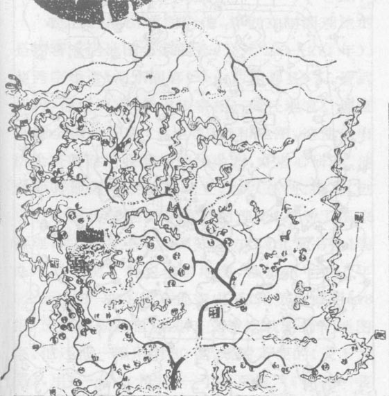
Figure 7 Topographical map unearthed from Mawangdui Han Tomb No. 3 in Changsha

Figure 8. The garrison map unearthed from the No. 3 Mawangdui Han Tomb in Changsha
These two maps not only show the level of map drawing in China at that time, but also reflect that the surveying technology and surveying mathematics at that time have reached a very high level.
It was Pei Xiu (AD 223-271), an outstanding cartographer in the Western Jin Dynasty, who theorized ancient cartography and created cartography theory.Pei Xiu, styled Ji Yan, was born in Wenxi, Wenxi (now Wenxi County, Shanxi).During the reign of Emperor Wu of the Jin Dynasty, he served as Sikong (equivalent to the prime minister) and concurrently as a local official.Local officials manage household registration, land, fields and maps throughout the country, which gives him the opportunity to consult the previous generation maps collected by the government and study them with great concentration.On the basis of the original map surveying and mapping, he summed up and improved them, and created the cartography theory of traditional Chinese cartography. For the sake of national governance, he made "the king knows the four directions without going to the court" ("Beitang Shuchao" Volume 96), He drew a new map of the whole country. From the fourth to seventh years of Taishi (AD 268-271), he completed 18 pieces of "Yugong Regional Map", which is the earliest atlas in written records in China and the world.He also used 80 pieces of silk, which is inconvenient to view, to shrink the "big map of the world" into a scale (equivalent to 1:1,800,000) at the ratio of "one is divided into ten miles, and one inch is a hundred miles" ("Book of Jin·Pei Xiu Biography"). Made "Abbot Picture".It is a pity that these precious historical maps have been lost long ago, but fortunately, Pei Xiu's cartography theory has been preserved to this day because it was included in "Book of Jin · Biography of Pei Xiu".
The cartography theory founded by Pei Xiu is called "the six principles of cartography", that is, the six principles that must be followed when drawing maps.That is, rate, accuracy, distance, high and low, side evil, and straightforward. "Score" is the scale, indicating that there must be a scale that reflects the length and width of the area in proportion; "Zhunwang" is the azimuth, which is used to determine the positional relationship between topography and features on the map; "Daoli" is the distance, used to Determine the distance between various places; "high and low", "square evil" (that is, square oblique), "circular and straight" (that is, straight and straight), it means that due to the change of terrain height and the obstruction of intermediate objects, the roads will have high and low However, the distance taken between the two places should be a horizontal straight line distance when drawing a map, so it is necessary to "adjust measures to the local conditions" and adopt the method of taking down the height, obliquely at the square, and straight at the roundabout , determine the horizontal straight-line distance, and draw the map.Pei Xiu also emphasized that these six principles are interrelated and mutually restrictive.The six are indispensable, and if any one is missing, it is impossible for the map to correctly reflect the real geographical situation.
These cartographic principles proposed by Pei Xiu are the basic scientific theories for drawing flat maps.These theories have been followed by later generations and influenced the traditional cartography of our country until the Qing Dynasty.
Figure 7 Topographical map unearthed from Mawangdui Han Tomb No. 3 in Changsha
Figure 8. The garrison map unearthed from the No. 3 Mawangdui Han Tomb in Changsha