
Chapter 5 Chapter 2 Unique Astronomical Coordinate System
The coordinate system established with the zenith (directly above the head) and the horizon circle as the basic point circle is called the horizon coordinate system, and the two coordinate components are horizon height and azimuth (see Figure 1).
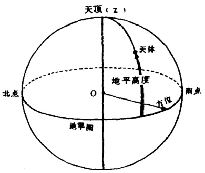
Figure 1 Horizontal coordinate system
The horizon height refers to the angular distance from the celestial body to the horizon along the great circle perpendicular to the horizon meridian, and the horizon is the starting point for calculation.For a long time in ancient China, length units such as zhang, chi, and inch were used to express the height of celestial bodies, and one inch was roughly equivalent to one degree.It was not until the Song Dynasty that the "degree" unit was used.
Azimuth is the direction, which can be marked on the horizon meridian circle.In the initial stage of the generation of the concept of orientation, there were only four directions of east, south, west, and north, which were represented by Mao, Wu, You, and Zi respectively.By the time of the Han Dynasty, it had increased to 12 directions, each named after twelve branches.Later, out of the need to improve measurement accuracy, four dimensions, eight stems, and twelve branches were used to represent 24 directions, of which the four dimensions were Gen [gen Gen], Xun [xun Xun], Kun, and Qian, respectively representing northeast, southeast, and southwest ,northwest.The eight stems are A, B, C, D, G, Xin, Ren, and Gui.The twelve branches are Zi, Chou, Yin, Mao, Chen, Si (si 4), Wu, Wei, Shen, You, Xu, and Hai (see Figure 2).Obviously, azimuth is only a regional concept. Taking "Zi" as an example, the range of 7.5° to the left and right of true north is called sub-azimuth. The "Zhou Bi [bi Close] Suan Jing" can be used as an exception, because the book uses a measurement method similar to the modern horizon longitude.In addition, the azimuth component of China's horizontal coordinate system does not have the problem of the starting point of measurement.
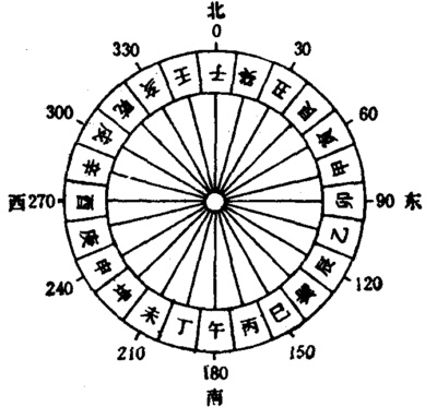
Figure 2 Twenty-four directions
Figure 1 Horizontal coordinate system
Figure 2 Twenty-four directions